
Places (POIs) visited during this tour
Place #1
Recommended Starting Point
Distance: 0.00mi
, Attraction : Hiking
100 Mitchell Canyon Rd, Clayton, CA 94517, USA
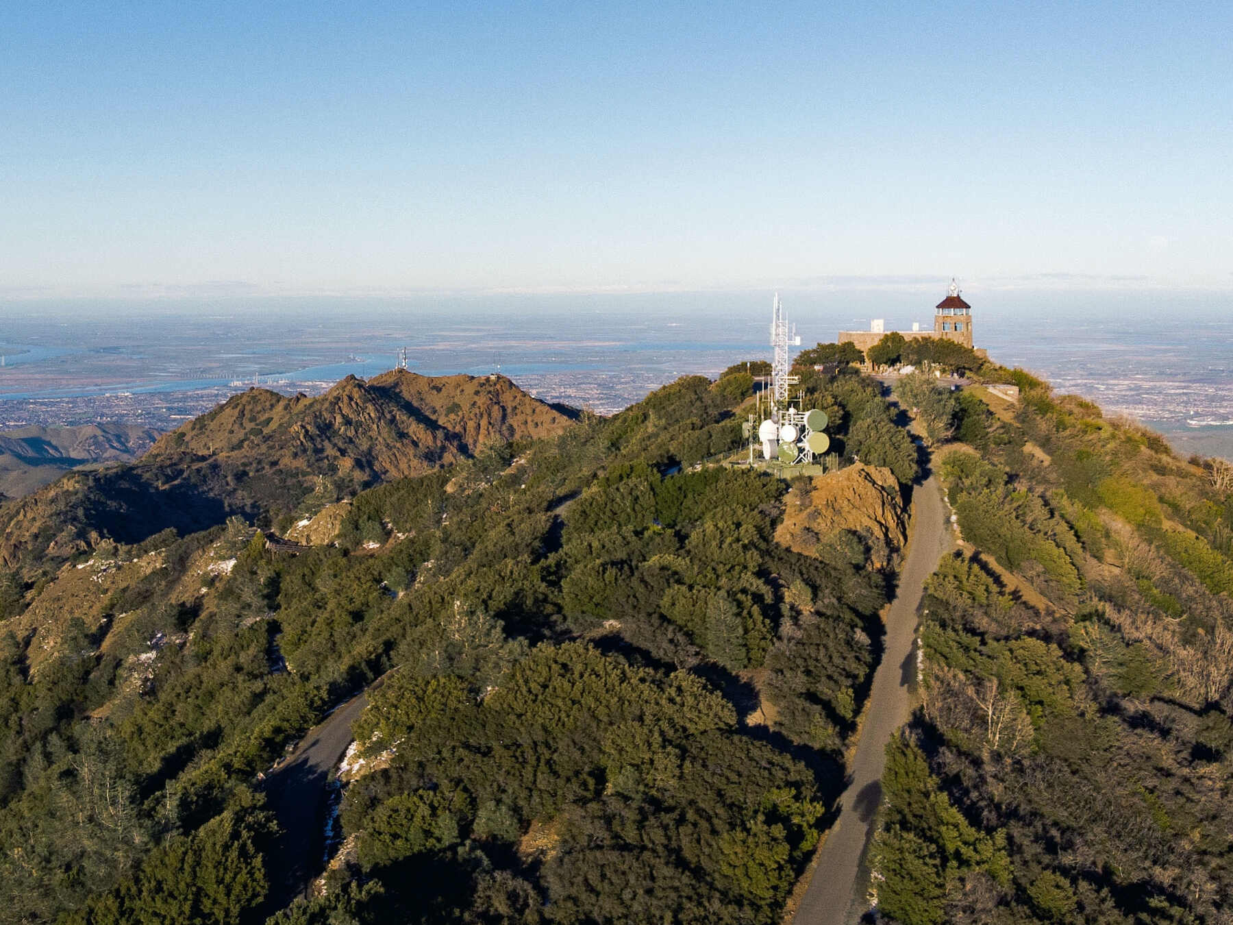
Mt. Diablo
Welcome to Contra Costa County! Our first hot spot to check out is Mt. Diablo – a popular peak to hike and camp at for all experience levels. This is a moderate hike and the trail is well marked. It is quite rocky with some parts being wide and some sections narrowing to a single-file track. It is recommended to start earlier in the day when temperatures are cooler.
The way up the mountain is long, but it’s well worth the climb. From the summit, you’ll enjoy a breathtaking 360-degree view. On a clear day, you can see all the way to the Golden Gate! A small museum at the summit occupies a lighthouse that guided planes to the Bay Area in the early 20th century.
Perhaps you’re wondering about the sinister name given to this peak? No need to be concerned. According to local lore, after arriving in the late 1700s, Spanish explorers and the accompanying soldiers nicknamed the area "Monte del Diablo." This term described the dense thicket of willows at the north end of the valley, which soldiers believed was possessed by spirits of the Bay Miwok people. As a result, the Spanish name "Monte del Diablo" was attributed and essentially translates to ‘thicket of the devil.’ Despite the name, I doubt you'll need an exorcism after you’ve reached the summit. Instead, your reward will be the rush that comes from conquering the mountain.
The Mitchell Canyon Visitors center, where you find yourself now, is the most popular spot to park for people who want to start their hike at the bottom and climb all the way up. For folks who want to enjoy the many trails and picnic spots throughout the park’s 20,000 acres, there are plenty of road entrances that allow you to drive into the park, even up to the summit itself!
Leaving the visitor center will take you north into our first city, Clayton.
The way up the mountain is long, but it’s well worth the climb. From the summit, you’ll enjoy a breathtaking 360-degree view. On a clear day, you can see all the way to the Golden Gate! A small museum at the summit occupies a lighthouse that guided planes to the Bay Area in the early 20th century.
Perhaps you’re wondering about the sinister name given to this peak? No need to be concerned. According to local lore, after arriving in the late 1700s, Spanish explorers and the accompanying soldiers nicknamed the area "Monte del Diablo." This term described the dense thicket of willows at the north end of the valley, which soldiers believed was possessed by spirits of the Bay Miwok people. As a result, the Spanish name "Monte del Diablo" was attributed and essentially translates to ‘thicket of the devil.’ Despite the name, I doubt you'll need an exorcism after you’ve reached the summit. Instead, your reward will be the rush that comes from conquering the mountain.
The Mitchell Canyon Visitors center, where you find yourself now, is the most popular spot to park for people who want to start their hike at the bottom and climb all the way up. For folks who want to enjoy the many trails and picnic spots throughout the park’s 20,000 acres, there are plenty of road entrances that allow you to drive into the park, even up to the summit itself!
Leaving the visitor center will take you north into our first city, Clayton.
Read More
Place #2
Distance: 1.97mi
, Attraction : Main Street
119015007, Clayton, CA 94517, USA
Clayton
Welcome to Clayton! This charming downtown area is the heart of this first city on our route. The first spot you’ll notice on your right is the Ipsen Family Bocce Park, which was created as a joint project between the eponymous Ipsens, the Clayton Business & Community Association, and Skippolini’s Pizza, located just next door. If you’ve never played bocce before, you should check it out sometime! Originating out of present-day Italy, Bocce is incredibly popular in the Balkan region of Eastern Europe and is the third most-played sport among Special Olympics athletes.
Further down the street, you’ll pass Cup O’Joe, a cozy cafe, the Clayton Club Saloon, with its daily happy hour specials, and Moresi’s Chophouse, a locally owned bistro. At the end of Main Street on the right, you’ll get a glimpse of the Grove, a city park with benches, picnic tables, and a playground for the kids. You’ll make a left at the end of Main Street, followed by another left on Clayton Road. Across the street, you may catch sight of the fairways of Oakhurst Country Club, whose 18-hole golf course winds its way through the canyons and valleys that surround Seeno Hill.
Clayton Road will take us out of the historic downtown and into Clayton’s more commercial area.
Further down the street, you’ll pass Cup O’Joe, a cozy cafe, the Clayton Club Saloon, with its daily happy hour specials, and Moresi’s Chophouse, a locally owned bistro. At the end of Main Street on the right, you’ll get a glimpse of the Grove, a city park with benches, picnic tables, and a playground for the kids. You’ll make a left at the end of Main Street, followed by another left on Clayton Road. Across the street, you may catch sight of the fairways of Oakhurst Country Club, whose 18-hole golf course winds its way through the canyons and valleys that surround Seeno Hill.
Clayton Road will take us out of the historic downtown and into Clayton’s more commercial area.
Tour itinerary stops | Additional places you'll see on this self-guided tour
Click below for full access to this tour
Have any questions about this tour? Or a general travel / self-guided tours question? That's completely natural
+ How long does this tour take?
Most travelers complete this tour in approximately 2.5 to 3 hours, depending on pace, time spent at each stop, and optional detours. Having said that, please remember that self-guided tours are extremly flexible (you can start, pause, continue anytime) and everyone has their own pace.
+ What does this tour include?
This self-guided driving tour includes 13 stops, covering top attractions such as Mt. Diablo, Clayton, Clayton Valley, Concord, Downtown Concord.
+ Where does the tour start?
The tour starts at Mt. Diablo (Address: 100 Mitchell Canyon Rd, Clayton, CA 94517, USA). You can begin the tour there or join from any stop along the route.
+ What type of tour is this?
This is a self-guided driving tour designed to be completed by car, covering scenic routes, city highlights and optional key stops.
+ Can I do this tour at my own pace?
Yes, this is a self-guided driving tour, so you can start anytime and explore at your own pace. You can pause, skip stops, or spend more time at places that interest you. You can even split it into multiple days. Explore however feels right for you. The only vaiables that might affect your pace are speed limits and traffic congestion.
+ Do I need a car for this tour?
Yes, this is a driving tour, designed to be completed by car, with stops spread across different locations connected by a driving route.
+ Do I need anything in order to take the tour?
There are two things that you need - 1. A mobile phone (with the UCPlaces app installed and active location services, and a cellular data plan with a decent signal for downloading the tour). 2. A car. Here are some recommendations for a great experience: 1. Make sure your phone is fully charged and bring a charging cable for your car. 2. Connect your phone to the car speaker system via bluetooth or use our CarPlay/Android Auto option for the best experience.
+ How will I navigate from point to point during the tour?
The tour uses GPS-based navigation through the UCPlaces app, with automatic audio playback and step-by-step directions between stops. This works great either directly from your phone, or while connected to your car's multimedia system and using our CarPlay or Android Auto options. Just follow the route and listen to the audio guide. Use the resume feature to continue from where you recently stopped (or closed the app). Easily skip or go back to stops.
+ Is this tour suitable for families or groups?
Yes, self-guided tours are ideal for families and small groups, allowing everyone to explore comfortably without being tied to a fixed schedule.
+ What makes a self-guided tour better than a guided tour?
Self-guided tours are more flexible, affordable, and personalized. You can avoid crowds, choose your pace, and focus on the stops that interest you most.
+ I installed the app and it's now asking for GPS and media access permissions, why?
The app is your tour-guide, it needs to know where you are located on the map to be able to trigger the points of interest. It also needs access to audio and media files to provide you with this experience.
+ What happens if there are unexpected roadblocks or navigation issues?
We have been working hard to deliver a great experience. Though you may run into unexpected obstacles (the world is constantly changing), our app has multiple features and mechanisms in place to help you overcome them, including: AI assistance, force play an audio if you can't reach the stop, skip or return to stops, automatic rerouting and more.
+ Can I take the tour in my language?
Though all of our tours are primarily in English, many tours are muyltilingual (including: Spanish, German, Portuguese, French, Japanese, Hebrew, French, Arabic and more...). The tour language options depend on the specific tour - You can easily check which languages are available in the tour screen!
) to use Force Play, Skip, and Back, for full flexibility.